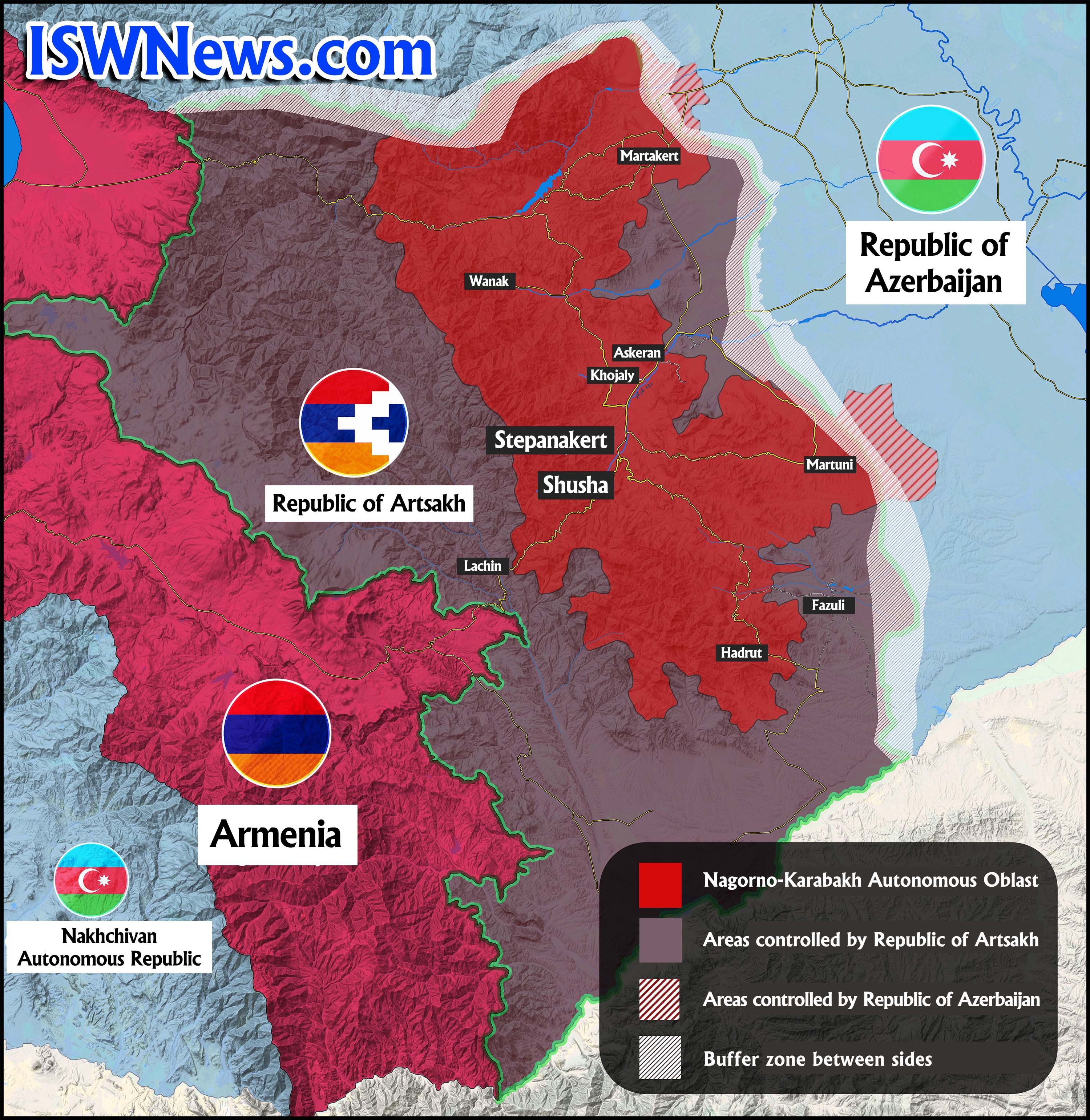
Overview of the Karabakh control lines + Map of Karabakh

In seventh century, a triangle area between river’s Kura, Aras and Zengezur mountain was called Karabakh. Terrain of the area is rich and includes prairies and high mountains. Near end of 18th century, local lord of the Karabakh was the most powerful lord among Caucasus lords but due to rampant diseases, many died or migrated, […]
In seventh century, a triangle area between river’s Kura, Aras and Zengezur mountain was called Karabakh. Terrain of the area is rich and includes prairies and high mountains. Near end of 18th century, local lord of the Karabakh was the most powerful lord among Caucasus lords but due to rampant diseases, many died or migrated, made Karabakh deserted.
At the dawn of USSR, upon request of Karabakh inhabitants, the area was divided into two. Low prairies were given to Azerbaijan and Armenian inhabited high mountains were self-governed as ” Nagorno-Karabakh Autonomous Oblast”.
After USSR dissociation and start of conflicts between Armenia and Azerbaijan at the beginning of 90s, it caused military confrontation that Armenia and Karabakh joint forces occupied some lands from Azerbaijan and Azerbaijani soldiers also occupied some lands from self-governed area near Khojavend and Maraga.
As indicated on the map, control lines in Karabakh are divided into several areas:
– Areas controlled by Republic of Artsakh including former self-governed area plus Azerbaijan occupied lands.
– Part of former self-governed area occupied by Azerbaijan.
– Buffer area between two sides which is indicated by white hatching area.
Although areas controlled by Republic of Artsakh are governed by local officials, but Armenia has the task of defending the area due to previous law. It is noteworthy that news of fire exchange and killing or injuring from both sides due to violation if the border is limited to this buffer zone and neither side have violated the lands of the other side.


Comment